
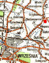
 Grzybowo is a
mid-size village situated 6 km northeast of Wrzesnia on
the road Wrzesnia-Witkowo. The impressive ramparts are clearly
visible approx. 400 meters to the west from the
elementary school, which is housed in an old manor of the
Lutomski family (see the red dot on the map). It is one of
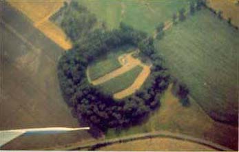
the largest fortified settlements built in the early Middle Ages
in Great Poland. The site covers an area of approx. 5
hectares. Even today, some segments of the ramparts reach a
height of 8.5 meters above the moat. They are overgrown with old
trees and dense bushes that has slowed erosion and contributed to
the excellent preservation of the site (see aerial photo). The
fortified settlement was surrounded by a number of villages (open settlements).
Grzybowo is a
mid-size village situated 6 km northeast of Wrzesnia on
the road Wrzesnia-Witkowo. The impressive ramparts are clearly
visible approx. 400 meters to the west from the
elementary school, which is housed in an old manor of the
Lutomski family (see the red dot on the map). It is one of
the largest fortified settlements built in the early Middle Ages
in Great Poland. The site covers an area of approx. 5
hectares. Even today, some segments of the ramparts reach a
height of 8.5 meters above the moat. They are overgrown with old
trees and dense bushes that has slowed erosion and contributed to
the excellent preservation of the site (see aerial photo). The
fortified settlement was surrounded by a number of villages (open settlements).
 The archaeological
excavation in Grzybowo has been conducted by Mariusz Tuszynski,
author of this WWW site, on behalf of the Poznan Society of
Friends of the Sciences. Dr. Zofia Kurnatowska from the Polish
Academy of Sciences acts as the scientific consultant.
The archaeological
excavation in Grzybowo has been conducted by Mariusz Tuszynski,
author of this WWW site, on behalf of the Poznan Society of
Friends of the Sciences. Dr. Zofia Kurnatowska from the Polish
Academy of Sciences acts as the scientific consultant.